360 Video & LiDAR Road Survey
XAIS-PTS Infrastructure Vision (iV) combines high-definition photographic imagery, LiDAR, and 3D mapping technology with leading asset management software and engineering expertise. It brings end-to-end efficiencies to the way road infrastructure data can be collected, visualised, and utilised.
Our 360 carriageway surveys leverage iV to make road infrastructure monitoring, auditing, planning, and maintenance more sustainable and cost-efficient. The data we collect is processed through machine learning to extract condition information and create an inventory of your infrastructure assets.
In addition, our XA© Asset Management Platform has been configured for iRAP - the international standard for road safety. The iRAP capabilities within XA© enable users to quickly inspect and code Star Rating attributes for roads to iRAP accreditation standards - transforming the way local authorities manage the condition and safety of infrastructure assets.

How We Carry Out 360 Carriageway Surveys
To collect thorough and accurate data on the condition of carriageways, XAIS-PTS iV imaging and mapping technology is incorporated into survey vehicles. As the vehicle travels across the network, it uses a GNSS / INS system and 360° panoramic camera to continuously capture high-definition panoramic imagery, GPS data, and orthophotos.
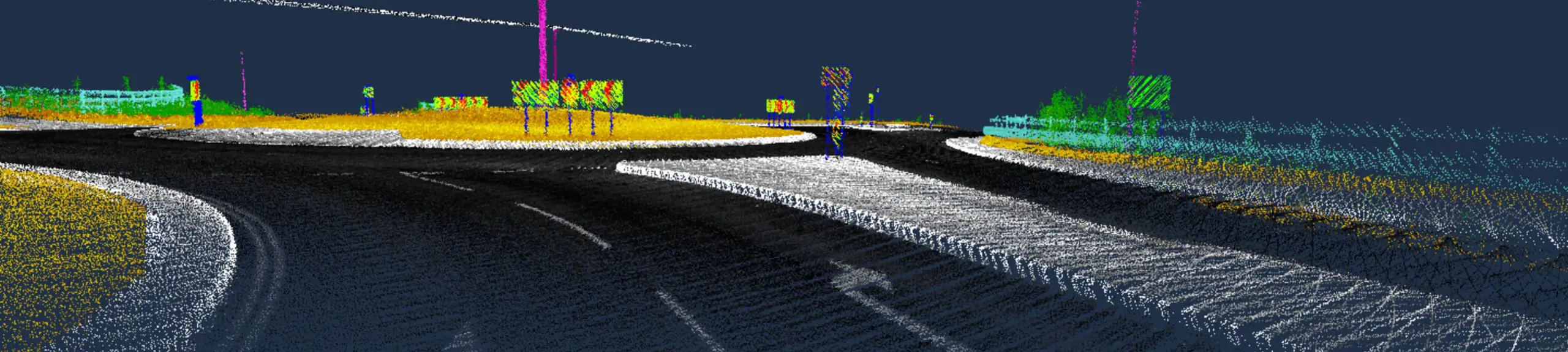
All our 360 carriageway survey vehicles are fitted with advanced LiDAR scanners. This technology enables us to carry out comprehensive video and LiDAR road surveys, which automatically record and collect the data required to build an accurate point cloud representation of the entire network and its surrounding area.
The point cloud data presents almost limitless possibilities, providing a comprehensive 3D mapping of the entire infrastructure network. It delivers precise measurements for bridge heights, clearance profiles, and location coordinates, as well as the geometry of road signs, roadside objects, safety barriers (VRS), embankments, drainage, visibility analysis, and more.

LiDAR Road Surveys: iRAP Rating
Following the mobile 360 carriageway survey, our cutting-edge artificial intelligence (AI) technology is applied to the visual data to collect the information required for condition rating of the infrastructure assets.
A key benefit of the accurate HD visuals and AI-driven defect detection capabilities is consistency. While human assessments allow for variations, discrepancies, or contrasting interpretations, results from our LiDAR road surveys are completely reliable.
Once complete, the data is then uploaded to the XA© Asset Management Platform, where it can be used to inform prioritisation and support funding applications.

iRAP Accreditation
Uniquely in the UK sector, XAIS-PTS combines our automated data capture and intelligent analysis capabilities with full iRAP Accreditation for its team and systems.
iRAP Accreditation powers the development of our cost-effective and sophisticated system, helping clients seamlessly collect, code, analyse, and present data from a principle or classified network / section. From this, we can deliver a range of critical asset management information, including full iRAP Star Ratings.
Importantly, XA© and iV not only collectively generate and present road safety data in line with the iRAP specifications but are also able to integrate this data with other established and award-nominated processes. These include SCRIM / SKID analysis, LASR crash modelling and the scheme-building functions developed with the XA© Scheme Assembler.
Benefits of a LiDAR Road Survey
Our 360 carriageway surveys record visual infrastructure assets and condition data in unrivalled detail, which can then be analysed at the desk to reduce the need for engineer site visits.
- Fully mobile
- Enhances efficiency
- Automatic data analysis
- Minimises carbon footprint
- Robust, reliable results
- Informs decision-making processes
If you have any queries or requests for surveys to support these areas, then please contact the team and we will be happy to assist you.
Frequently Asked Questions
How long does a 360-video and LiDAR survey take?
LiDAR scanners can collect a million points of data per second, making it an extremely fast method of surveying. The duration of a LiDAR road survey will depend on the size and complexity of the designated network. However, the survey usually covers 25 - 50km per day dependant on the nature of the carriageway network.
What is the iRAP safety rating?
The International Road Assessment Programme (iRAP) star rating protocol is a way to measure how safe our highways are. Star ratings are determined by independently gathered road inspection data and provide a simple, objective measure of the road’s level of safety. Highest-risk roads are 1-star rated, while least-risk roads are 4 or 5-star rated.